| Size | 53.2 square miles | ||||||
| Source | In West Cornwall Township, just northeast of Mt. Gretna | ||||||
| Mouth | Empties into Susquehanna River, just north of Falmouth | ||||||
| Counties | Dauphin, Lancaster, Lebanon | ||||||
| Municipalities |
|
||||||
| Land Use | 53% agriculture. Other land uses include: residential, commercial/industrial and state game lands. | ||||||
| Features of Interest | Trout stocking, Conewago Recreational Trail, Lebanon Valley Rails-to-Trail, Horse-Shoe Trail, Governor Dick, State Game Lands No. 145. | ||||||
| Protected Uses | Water supply, recreation, aquatic life (Trout Stocking Fishery) | ||||||
| Stream Assessment | Aquatic biological surveys conducted in 1994 and 1997 by aquatic biologists for Susquehanna River Basin Commission. Assessment concluded that Conewago Creek is “impaired” (i.e., does not meet its designated use for protection of aquatic life). | ||||||
| Impaired Segments (1998) | 15.8 miles of Conewago Creek 11.2 miles of Lynch Run 5.7 miles of Hoffer Creek 3.6 miles of unnamed tributary to Conewago Creek 5.1 miles of unnamed tributary to Conewago Creek | ||||||
| Causes of Impairment | Sediment, nutrients from runoff | ||||||
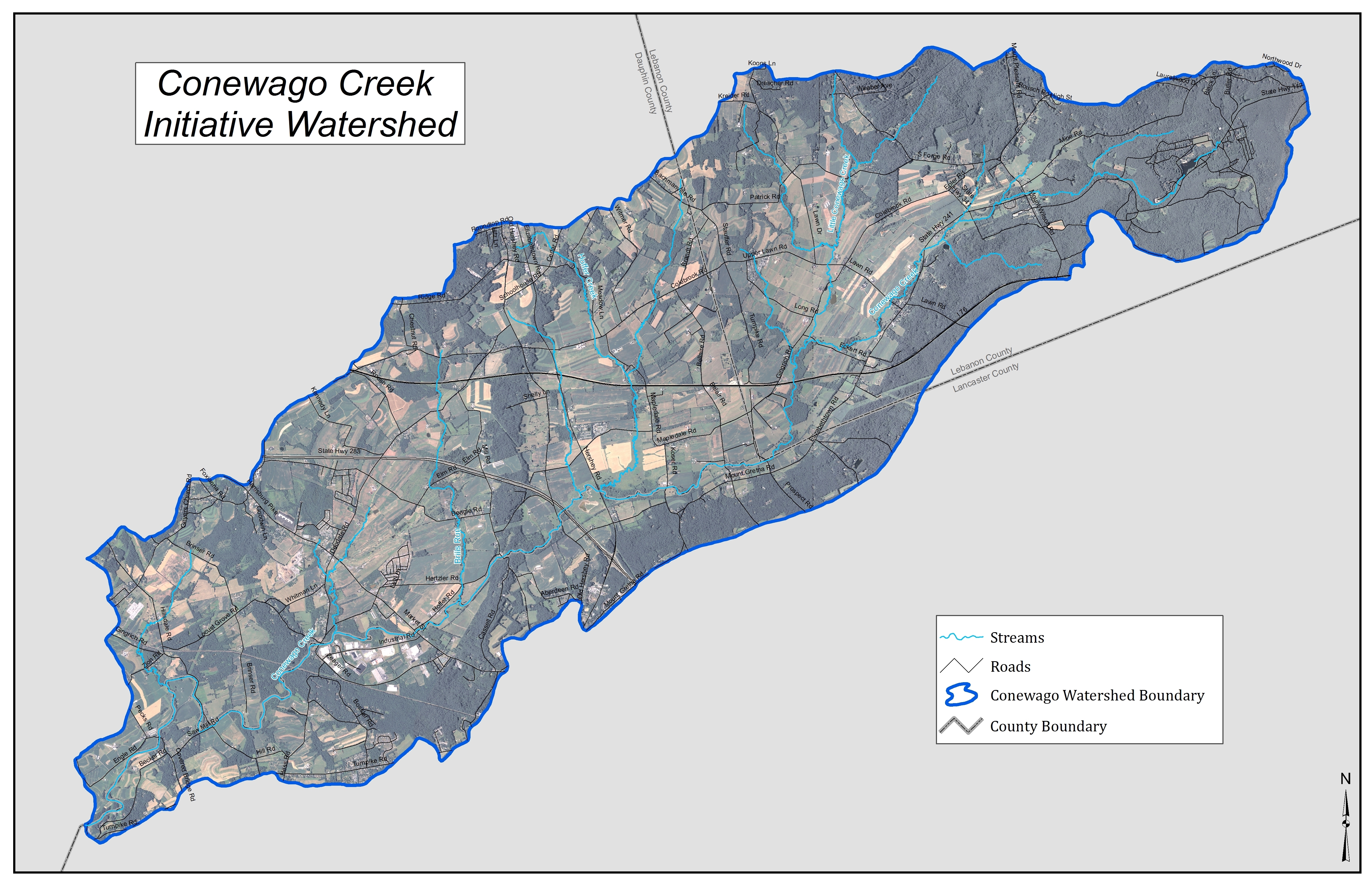
What is the Conewago Creek Watershed? A “watershed” is the geographic land area from which water drains toward a common watercourse in a natural basin. Thus, the Conewago Creek Watershed is the entire land area from which the Conewago Creek and its tributaries drain. It includes both the water itself and the land surrounding it.
The Conewago Creek Watershed encompasses a 53.2 square mile area in the rolling farm hills and woodlands of Lancaster, Dauphin and Lebanon Counties, Pennsylvania. Its headwaters are just northeast of Mt. Gretna, in the western portion of West Cornwall Township, Lebanon County. It empties into the Susquehanna River just north of the village of Falmouth. The upper portion of the Conewago flows through Lebanon County, while the middle and lower sections form the boundary between Dauphin and Lancaster Counties. The Conewago’s main tributaries include the Little Conewago Creek, Hoffer Creek, Brills Run and Lynch Run.
Parts or all of ten municipalities are located within the Conewago Creek Watershed:
- Lebanon County
- West Cornwall Township
- Borough of Mt. Gretna
- South Annville Township
- South Londonderry Township
- Lancaster County
- Mt. Joy Township
- West Donegal Township
- Borough of Elizabethtown
- Conoy Township
- Dauphin County
- Conewago Township
- Londonderry Township
Uses in the Watershed The primary land use in the Conewago Creek Watershed is agricultural. Additional land uses include residential and industrial/commercial. The Conewago Industrial Park is located in the middle to lower section of the Watershed. Much of the upper portion of the Watershed is heavily forested and consists of public Game Lands maintained by the Pennsylvania Game Commission.
There are several hiking and biking trails available for use in the Watershed. These include the Conoy Canal Trail, the Conewago Recreational Trail, the Lebanon Valley Rails-to-Trail, the Horse-Shoe Trail, Governor Dick, and various trails throughout Game Lands No. 145. Conewago Lake in Mt. Gretna is open to the public for swimming in the summer. Fishing opportunities are also available. The upper portion of the Conewago is stocked with trout, while the lower portions contain smallmouth bass, pickerel, bluegill and rock bass. If you are interested in fishing the Conewago, please seek permission from the landowner and respect private property!
The Conewago: An Impaired Watershed In 1994 and again in 1997, aquatic biologists from the Susquehanna River Basin Commission assessed the Conewago and its tributaries. The biologists found that the majority of the Watershed is impaired. In other words, it is too polluted to sustain the kind of fish and other aquatic life that it could sustain if it were a healthy stream. The results of the assessment identified increased sediment and nutrients from runoff as the major cause of impairment.
Because of the SRBC’s assessment, in 1998, the Conewago was placed on Pennsylvania’s 303(d) list, a list of impaired waterways throughout the Commonwealth. The following segments of the Conewago and its tributaries are on the list:
- 15.8 miles of Conewago Creek (from mouth to confluence with Little Conewago)
- 11.2 miles of Lynch Run
- 5.7 miles of Hoffer Creek
- 3.6 miles of unnamed tributary to Conewago Creek
- 5.1 miles of unnamed tributary to Conewago Creek